In the late 1800s/early 1900s, as miles of new streets were laid in Montclair, the genesis of many street names was fairly obvious. As time passed, the context for those names became less clear, but here are a few of the stories behind our town’s street names:
Church Street was named for Old First Presbyterian Church, built circa 1856, which dominated the triangular-shaped site adjacent to Bloomfield Avenue where the Hinck Building is today.

Old First Presbyterian Church, early 1900, Church Street at Bloomfield Avenue
Christopher Street, built circa 1900, was named for Christopher Hinck who developed the residential street advertised as a “two minute walk from the train station.”
Native American-inspired street names include Watchung (“sheltered by the mountain”) Avenue; Nishuane (“two creeks”) Road; and Yantecaw (“place of dancing”) Brook Road.
The Oakcroft neighborhood near Anderson Park was developed circa 1906 by Aaron W Godfrey. In addition to the road he named eponymously, Princeton Place honors his alma mater. Several other streets Godfrey developed in Montclair — Patton Place and Nassau Road — are nods to past Princeton University presidents, as are McCosh, Maclean, Hibben, Edwards, and Witherspoon in Clifton’s Montclair Heights section, off Valley.
Normal Avenue was named in 1908 for the newly-constructed State Normal School; colleges for teacher preparation were called “normal schools” at that time. It had formerly been Fifth Street. College Avenue, formerly Smith Street, runs perpendicular to Normal Avenue and was also renamed at that time. Two additional college-themed streets in the neighborhood: Amherst Place and Hamilton Terrace.
Additional college-related streets include Harvard, Stanford, Cambridge, Oxford between Grove and Ridgewood Avenue; Rutgers Place and Cornell Way, near in the northeastern part of town; and Yale Terrace, south of Watchung School.
Club Road and The Fairway were built on the former Upper Montclair Country Club, near the Grove Street/Bellevue Avenue intersection.
St. Luke’s Place is the street on which an earlier St. Luke’s Episcopal Church was located, approximately 1869-1889.
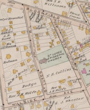
1890 Montclair Township map, St. Luke’s Place
Label Street was named for Samuel Crump’s label factory near the Walnut Street train station. Wheeler Street is in the vicinity of former Wheeler Mill southeast of the Bloomfield Avenue/Maple Street area.

1878 township map, Label Street
Erie Street runs parallel to the Erie Railroad tracks near the Walnut Street Station; Greenwood Avenue, opposite the station, was likely named for the Greenwood Lake Railway Line which preceded the Erie. Lackawanna Plaza, formerly Spring Street, is adjacent to the former Lackawanna Station on Bloomfield Avenue.
Some streets honor esteemed residents: Bradford Avenue (Rev. Benjamin Bradford), formerly Van Gieson’s Gap; Rand Place (Jasper Rand, active in township affairs and member of philanthropic family).
Many streets carry a landowner’s surname (sometimes first name): Baldwin Street; Brainard Street; Frink Street; Harrison Avenue; James Street (James Andrus); Jerome Place (Jerome Sigler); Cooper Avenue; Gates Avenue; Inness Place; McDonough Street; Porter Place; Seymour Street (John Seymour and Ira Seymour Crane); Van Vleck Street; Wilde Place; William Street (after development partners William Sigler and William Jacobus); and others.
Llewellyn Road, formerly Park Street, was renamed to create a connection with Llewellyn Park in West Orange.
Montclair’s geography inspired Highland Avenue, Hillside Avenue, Undercliff Road, Crestmont Road, Edgecliff Road, Rockledge Road, and all varieties of Mountain. Central Avenue and Midland Avenue, on the other hand, are centrally located.
Tree-related street names include Cedar Avenue, Cherry Street(no longer existing), Chestnut Street, Elm Street, Maple Avenue, Pine Street, Willow Street, and multiple streets inspired by the oak tree.
Mt. Hebron Road derives its name, from the Old Testament and meaning “friendship,” from a Sunday School established in the the area in the 1820s.
Orange Road became the official name of “the road to Orange.” South Fullerton, another road to Orange, was named for the family that owned a large parcel of land; it was also called “the road to Doremus store” depending on which direction a traveler was going.
Valley Road had formerly been called Speertown Road. It was laid out in 1768 to connect Speertown (today’s Upper Montclair) to Cranetown (south of Watchung Avenue).
Glenridge Avenue was formerly called the Old Road [to Newark].

1881 Map, Old Road (Glenridge Avenue) and Bloomfield Avenue
Bloomfield Avenue began as Crane’s Gap, a natural passage through First Mountain near today’s Montclair/Verona border. Perhaps used first as a Native American trail, in 1806 Israel Crane improved the road from Pine Brook to Newark and named it the Newark and Bloomfield Turnpike. In 1871, Essex County purchased the road and renamed it Bloomfield Avenue in 1891.